

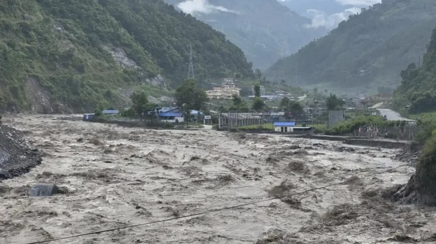
Central Nepal floods and flash floods are major natural hazards shaped by Himalayan geography, intense rainfall, steep river gradients, unstable slopes, glacial processes and concentrated development along river corridors. The subject has gained renewed international attention following the catastrophic 26 August 2026 Bhote Koshi flood near Nepal’s northern border.
- What are Central Nepal floods and flash floods?
- Why is Central Nepal particularly vulnerable to flooding?
- What caused the Central Nepal flash flood on 26 August 2026?
- Which areas were affected by the Central Nepal floods?
- How severe were the Central Nepal floods?
- How do flash floods develop in Himalayan river systems?
- What damage can Central Nepal floods cause?
- How do glaciers and glacial lakes contribute to flood risk?
- What does research say about future Himalayan flood risk?
- How can Nepal improve flood forecasting and early warning?
- What should people do during a Central Nepal flash flood?
- What is the historical context of major floods in Central Nepal?
- What does the Central Nepal flood risk mean for the future?
The latest disaster demonstrates why flooding in Nepal cannot be understood only as heavy rainfall. Mountain floods often involve interacting hazards. A glacial collapse, landslide, debris avalanche, river surge and infrastructure failure can occur within the same event.
For readers in Glasgow and elsewhere in the UK, understanding Central Nepal floods provides useful context for international disaster reporting, Himalayan climate risks, tourism safety and the vulnerability of mountain communities.
What are Central Nepal floods and flash floods?
Central Nepal floods are rapid, high-energy water and debris events affecting mountain valleys and downstream settlements. The 26 August 2026 disaster began near the Nepal-China border and travelled through Bhote Koshi and Trishuli river systems during extreme Himalayan hazard conditions.
Flooding in Central Nepal occurs through several physical processes. River flooding develops when water levels exceed a river channel’s capacity. Flash flooding develops much faster and can produce dangerous flows within a short period.
Central Nepal contains steep Himalayan terrain where rivers descend rapidly through narrow valleys. This geography gives floodwater substantial hydraulic energy. When sediment, rocks, trees, ice and landslide material enter a river, the flow becomes heavier and more destructive.
The Bhote Koshi River is a major Himalayan river system flowing through northern Nepal. The Trishuli River is another major river corridor that carries water southward through central Nepal.
The 2026 disaster involved both river flooding and a major debris-flow process. The United States Geological Survey stated that the event was likely triggered by rapid slope failure involving a glacier in Langtang National Park, near the China border.
This distinction matters because a flash flood created by a sudden high-altitude collapse behaves differently from ordinary seasonal river flooding.
Why is Central Nepal particularly vulnerable to flooding?
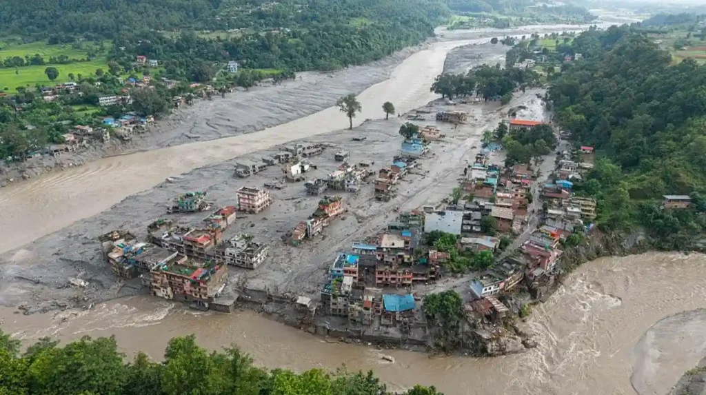
Central Nepal is vulnerable because steep Himalayan slopes, narrow valleys, intense rainfall, glacial ice, unstable sediments, and dense river networks concentrate water and debris quickly. Roads, bridges, hydropower facilities, settlements, and border infrastructure often occupy flood-prone corridors across the region.
Nepal’s physical geography creates strong flood exposure. The country extends from lowland plains to some of the world’s highest mountains across a relatively short horizontal distance.
The Himalayan region contains steep slopes and deeply incised valleys. Rivers therefore move through confined channels rather than broad, low-gradient floodplains in many mountain locations.
Rainfall is another major factor. Nepal receives most of its annual precipitation during the South Asian summer monsoon. The World Bank identifies June to September as the country’s principal rainy period and notes that flash floods can be triggered by heavy or sustained rainfall, rising river volumes and inadequate drainage.
Mountain communities also face secondary hazards. Landslides can block rivers. Blocked rivers can form temporary lakes. When those barriers fail, large volumes of water and sediment can move downstream suddenly.
Infrastructure increases exposure when roads, bridges, hydropower installations and settlements are constructed close to river channels. Damage to one bridge can also obstruct rescue routes and isolate communities.
The combination of natural hazards and infrastructure exposure explains why a relatively concentrated mountain event can produce consequences across several districts.
What caused the Central Nepal flash flood on 26 August 2026?
The 26 August 2026 flood was linked to a catastrophic glacial collapse in Langtang National Park, near the China border. USGS analysis identified rapid slope failure and reported that the resulting debris flow travelled nearly 100 kilometres downstream rapidly.
The USGS identified a source area on the northern side of Langtang Lirung, a mountain approximately 7,200 metres high. Seismic analysis indicated that the collapse generated energy equivalent to a magnitude 5.2 earthquake.
The physical sequence involved rapid slope failure followed by a debris-rich flow. Ice, rock and sediment entered downstream drainage systems and increased the destructive force of the flood.
The event travelled almost 100 kilometres through populated areas. The USGS reported impacts along the Bhote Koshi and Trishuli river systems and at infrastructure including the Rasuwagadhi border area.
The event therefore represents more than conventional monsoon flooding. It demonstrates a cryospheric hazard, meaning a hazard involving snow, ice or glaciers, transforming into a hydrological disaster.
Scientists continue to assess the precise geological sequence and the role of changing Himalayan environmental conditions. Initial USGS findings provide the clearest scientific description of the trigger currently available.
Which areas were affected by the Central Nepal floods?
The flood affected Rasuwa first, then sent dangerous water and debris downstream through river corridors. Official reporting identified impacts in Rasuwa, Nuwakot, Dhading, and Gorkha, while the wider Trishuli system carried risks farther downstream and required monitoring during emergencies.
Rasuwa District was at the centre of the initial disaster. The district borders China and contains important mountain transport and trade routes.
The flood then affected downstream river corridors. Nepal’s Ministry of Home Affairs reported severe impacts in Rasuwa, Nuwakot, Dhading and Gorkha districts.
The river system also created concerns farther downstream because water and debris can continue moving after the initial mountain collapse.
The geography explains why emergency management cannot focus only on the location where a flood begins. A high-altitude failure can create hazards dozens of kilometres downstream.
The 2026 event also affected areas connected to international travel. The Nepal Ministry of Foreign Affairs reported that both Nepali citizens and foreign tourists were among those missing after the disaster.
This international dimension is particularly important for tourism authorities, embassies, travel operators and families attempting to establish the safety of travellers.
How severe were the Central Nepal floods?
Official figures changed rapidly as rescue teams recovered bodies and verified missing-person reports. Nepal’s Ministry of Foreign Affairs reported 538 recovered bodies on 28 August, while many people remained missing during continuing identification and field verification operations as rescue continues.
Casualty figures changed significantly during the first days because floodwater swept people and vehicles downstream, infrastructure was destroyed and some affected locations remained difficult to access.
Nepal’s Ministry of Foreign Affairs reported 538 recovered bodies in its 28 August update. The ministry also stated that search-and-rescue operations remained active and that people were still missing.
Earlier official reporting had recorded 349 recovered bodies on 27 August.
These changing figures demonstrate why disaster statistics should always be linked to a date and issuing authority.
The humanitarian consequences include deaths, missing people, displacement, damaged homes, destroyed transport routes, disrupted communications and damaged critical infrastructure.
The disaster also affected foreign nationals. Nepal’s official updates included people from multiple countries among those reported missing.
For international readers, this means casualty numbers should not be treated as final until authorities complete identification and reconciliation processes.
How do flash floods develop in Himalayan river systems?
Flash floods form when water enters a river or drainage channel faster than the channel can carry it. In mountain terrain, steep gradients accelerate flow, while landslides, ice, rock, sediment, and debris increase depth, force, blockage, and destructive energy downstream.
A flash flood can develop through intense rainfall, rapid snowmelt, glacier-related processes, landslide-dam failure or glacial lake outburst flooding.
The process becomes especially dangerous in steep mountain valleys.
Water released at high elevation accelerates as it moves downhill. The river then collects sediment and debris from surrounding slopes. This increases the density and destructive capability of the flow.
A landslide can temporarily block a river. Water accumulates behind the blockage. When the barrier fails, the stored water can produce a sudden downstream surge.
A glacial lake outburst flood, or GLOF, occurs when water stored in a glacial lake is suddenly released. Nepal contains thousands of glacial lakes, although only some present significant downstream exposure.
The 2026 event is especially important because USGS evidence points to glacial slope failure rather than a simple rainfall-driven flood.
What damage can Central Nepal floods cause?
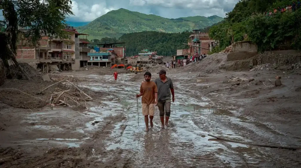
Flooding damages homes, roads, bridges, hydropower facilities, communications, farmland, businesses, and public services. The 2026 event also disrupted border connectivity and affected tourists and local residents, demonstrating how one mountain hazard can create cascading humanitarian and economic impacts across communities.
Flood damage is not limited to water entering buildings.
High-energy flows can remove foundations, undermine bridge supports and destroy roads. Sediment can bury buildings and agricultural land. Rocks and debris can damage turbines, power stations and water infrastructure.
The 2021 Melamchi flood provides an important historical example. The World Bank reported that heavy rainfall, rapid snowmelt, erosion and landslide processes contributed to severe downstream flooding. Water and debris travelled approximately 40 kilometres along the Melamchi River.
The 2026 disaster similarly demonstrates the cascading nature of Himalayan hazards.
When roads disappear, emergency vehicles cannot reach isolated communities. When bridges collapse, people on opposite sides of rivers lose direct access to hospitals, markets and evacuation centres.
When hydropower facilities are damaged, electricity generation and local economic activity can also be affected.
The loss of transport infrastructure has wider consequences because northern Nepal contains routes connecting communities with the China border.
How do glaciers and glacial lakes contribute to flood risk?
Glacial hazards add another pathway to flooding because ice, rock, and sediment can fail suddenly at high elevations. A collapse can dam or redirect water, release stored meltwater, and create a debris-rich surge that reaches downstream communities with limited warning.
Glaciers are dynamic bodies of ice. Their movement, melting and interaction with surrounding rock influence Himalayan landscapes.
Climate warming is contributing to glacier retreat across the Himalaya. Retreat can expose unstable slopes and contribute to the development or expansion of glacial lakes.
A glacial lake outburst flood occurs when a natural barrier holding a glacial lake fails. The resulting release can send a large volume of water downstream.
However, not every Himalayan flood is a GLOF. The 2026 Nepal event has been described by USGS as a debris avalanche and flood likely triggered by rapid slope failure involving a glacier.
This distinction is scientifically important.
The event also created concerns about additional water bodies formed by debris blockage. Reuters reported on 28 August that Nepalese authorities were monitoring two lakes upstream of the affected zone because continued water accumulation presented a further flood risk.
Such secondary hazards make post-flood monitoring essential even after the main surge has passed.
What does research say about future Himalayan flood risk?
Climate change is increasing concern about Himalayan flood risk through changing precipitation, glacier loss, snow and ice instability, and altered runoff. Research shows that Central Himalayan flood hazards require combined climate, hydrological, geological, exposure, and infrastructure assessments under changing conditions.
Scientific research identifies Central Himalayan river systems as highly sensitive flood environments.
A 2025 study in Scientific Reports examined future flood hazards in the Karnali River system using climate projections, hydrological modelling and flood-frequency analysis. The researchers described the Central Himalayan floodplain as one of the world’s most flood-affected regions.
The same study reported that the September 2024 floods caused damage equivalent to approximately 1% of Nepal’s GDP, with 236 deaths and 8,400 displaced people.
Another 2024 Scientific Reports study examined flash flooding across the Himalayan region. It highlighted the importance of atmospheric conditions, topography, remote sensing and real-time monitoring for understanding flash-flood processes.
Climate change does not mean every individual flood is directly caused by global warming. Floods have always occurred in the Himalaya.
The stronger scientific conclusion concerns changing risk factors. Glacier retreat, altered precipitation, extreme rainfall, changing runoff and increased exposure can interact and change the overall hazard environment.
The World Bank also projects changes in precipitation patterns and extreme rainfall across Nepal, reinforcing the importance of climate-resilient flood planning.
How can Nepal improve flood forecasting and early warning?
Authorities reduce flood losses through rainfall and river monitoring, hazard mapping, warnings, evacuation, resilient infrastructure, land-use controls, emergency communications, and coordinated rescue. Satellite imagery and hydrometeorological observations provide critical information when roads and river corridors become inaccessible during rapidly evolving flood emergencies.
Early warning systems are one of the most important tools for reducing disaster deaths.
Nepal has invested in hydrometeorological monitoring and forecasting systems. The World Bank has highlighted the importance of improved weather observations, flood forecasting and early-warning services for reducing the impact of climate-related hazards.
Satellite imagery has an important role when ground access is lost.
Following the 2026 disaster, USGS geologists used satellite imagery to map the flood and debris-flow extent. Comparing images from before and after the event helps identify inundated areas and damaged terrain.
Early warning must also connect scientific information with communities.
A warning has limited value if residents do not receive it, understand it or have a safe evacuation route.
Effective systems therefore combine sensors, forecasts, river gauges, telecommunications, local authorities and community preparedness.
The same principle applies to post-event monitoring. A flood can create new landslide dams or lakes that introduce additional hazards after the original event.
What should people do during a Central Nepal flash flood?
People near rivers should treat sudden water-level changes, roaring water, debris, damaged bridges, and official warnings as immediate danger signals. The safest response is to move to higher ground, avoid crossings, follow evacuation instructions, and remain away from unstable slopes.
Flash floods require immediate action because water levels can rise rapidly.
People should move away from river channels when authorities issue warnings. Crossing flooded roads or bridges creates serious danger because fast-moving water can undermine surfaces and carry vehicles or people downstream.
Residents should follow instructions from Nepal’s disaster-management authorities, police, army, local government and emergency services.
People should also avoid landslide-prone slopes after flooding. Saturated ground can remain unstable after rainfall or a major river event.
Tourists face additional challenges because they often do not know local geography. Visitors should follow official travel warnings and instructions from guides, accommodation providers and local authorities.
Communication is also important. Families searching for missing people should rely on verified government and consular information rather than unconfirmed social-media casualty figures.
The official Nepal Ministry of Foreign Affairs updates demonstrate why casualty and missing-person information should be checked against dated government releases.
What is the historical context of major floods in Central Nepal?
Nepal has experienced major floods for decades, with historical disasters showing recurring links between monsoon rainfall, steep terrain, landslides, river exposure and infrastructure vulnerability. The 1993 Central Nepal floods, 2017 monsoon floods and 2021 Melamchi disaster remain important reference events.
Historical evidence shows that Central Nepal’s flood risk predates current climate-change discussions.
The World Bank records severe flooding in July 1993 when more than 700 people were killed in Central Nepal.
The 2017 Nepal floods demonstrated the vulnerability of transport infrastructure. The World Bank noted that monsoon flooding damaged bridges, including structures along the East-West Highway.
The 2021 Melamchi flood became another major reference point. Heavy rainfall affected the Melamchi watershed and contributed to extensive damage downstream.
The 2024 floods added another major example. Research published in 2025 recorded 236 deaths and 8,400 displaced people during the September 2024 floods.
These events demonstrate a consistent pattern.
Flood risk results from the interaction between natural processes and human exposure. Rivers need space to carry water. When development occupies vulnerable corridors, the consequences of flooding increase.
Historical flood records therefore remain essential for infrastructure design, emergency planning and land-use decisions.
What does the Central Nepal flood risk mean for the future?
The long-term significance of Central Nepal floods extends beyond individual disasters. Better early warning, resilient roads and bridges, safer settlement planning, glacier monitoring, floodplain management, and regional cooperation are essential for reducing future losses across Himalayan river corridors.
Future flood management requires a multi-hazard approach.
Flood forecasting should operate alongside landslide monitoring, glacier observation, rainfall measurement and river-level monitoring. Treating each hazard separately leaves important gaps.
Infrastructure standards also require attention. Bridges, roads, hydropower facilities and communication networks need designs that account for high sediment loads, debris impacts and extreme river flows.
Land-use planning is equally important. Development in narrow river corridors increases exposure and reduces available space for floodwater.
The World Bank has identified urban development, inadequate zoning, building practices, deforestation, mining, erosion and blocked drainage as factors that can compound flood risks in Nepal.
International cooperation also has a role because Himalayan rivers cross political boundaries. The 2026 event affected both Nepal and China, demonstrating that upstream geological events can create downstream consequences across borders.
Research, satellite observation and improved communication systems will remain central to future disaster preparedness.
For international audiences, including readers in Glasgow, Central Nepal’s floods illustrate the importance of understanding climate-related hazards through evidence rather than isolated headlines. The most useful approach combines geology, hydrology, climate science, infrastructure planning, emergency management and verified disaster information.
The central lesson is clear: Central Nepal’s flood risk is produced by interacting mountain processes and human exposure. Reducing losses therefore requires equally integrated planning.
What caused the Central Nepal floods in 2026?
The 26 August 2026 Central Nepal disaster was linked to a rapid glacial slope collapse near Langtang Lirung in Rasuwa District. The resulting debris avalanche and flash flood travelled downstream through the Bhote Koshi and Trishuli river systems.