
The best route to walk along the River Clyde in Glasgow is the Glasgow-to-Cambuslang section of the Clyde Walkway, starting around the Riverside Museum and continuing east through the city centre, Glasgow Green, Dalmarnock and Cuningar Loop towards Cambuslang. The section covers about 14.5 kilometres (9 miles) and takes approximately 3.5 to 4 hours at a steady walking pace.
- What is the Clyde Walkway?
- Where is the best place to start the River Clyde walk in Glasgow?
- How long is the Glasgow to Cambuslang Clyde Walkway?
- What landmarks can you see along the River Clyde route?
- How does the route pass through Glasgow Green?
- What is the route like between Glasgow Green and Dalmarnock?
- Is the River Clyde walk suitable for beginners?
- Is the Clyde Walkway good for running and cycling?
- Can you walk the Clyde route with a dog?
- Which bridges are important on the River Clyde walk?
- What industrial history can you see beside the Clyde?
- How has the River Clyde waterfront changed?
- What is the best one-way route for a first-time visitor?
- Are there shorter River Clyde walks in Glasgow?
- What should you know before walking the River Clyde route?
- What is the final recommended River Clyde walking route?
The route provides a concentrated view of Glasgow’s riverside geography, industrial heritage, bridges, regenerated waterfront, parks and modern architecture. It also connects with major public transport locations, making it practical as a one-way walk rather than requiring a return journey on foot.
The wider Clyde Walkway is a 65-kilometre long-distance trail between Glasgow city centre and New Lanark. Scotland’s Great Trails identifies it as a linear route with approximately 720 metres of total ascent, normally completed over three to five days.
For visitors who want a manageable Glasgow riverside walk, however, the first section is the most practical choice. It stays close to the Clyde, passes major landmarks and has straightforward public transport access at both ends.
What is the Clyde Walkway?
The Clyde Walkway is a 65-kilometre riverside trail linking Glasgow city centre with New Lanark in South Lanarkshire. It combines urban waterfront paths, parks, woodland, farmland, historic sites and the Clyde Valley, with the Glasgow-to-Cambuslang section providing its main city walking experience.
The Clyde Walkway is a long-distance walking route following the River Clyde through Glasgow and the Clyde Valley. It was developed as a joint route involving Glasgow City Council, South Lanarkshire Council and North Lanarkshire Council.
The trail begins in the Glasgow area and continues through increasingly rural landscapes before reaching New Lanark, a UNESCO World Heritage Site. The route changes substantially along its length.
Within Glasgow, the setting is predominantly urban. Walkers pass bridges, former industrial land, modern developments, cultural venues and public parks. Further east, the landscape becomes greener and more rural.
The official Scotland’s Great Trails listing gives the full route a distance of 65 kilometres, around 720 metres of ascent, and a typical completion period of three to five days.
This distinction is important when searching for the “best River Clyde walk in Glasgow”. The entire Clyde Walkway is a long-distance trail, while the Glasgow-to-Cambuslang section works as a standalone city walk.
Where is the best place to start the River Clyde walk in Glasgow?
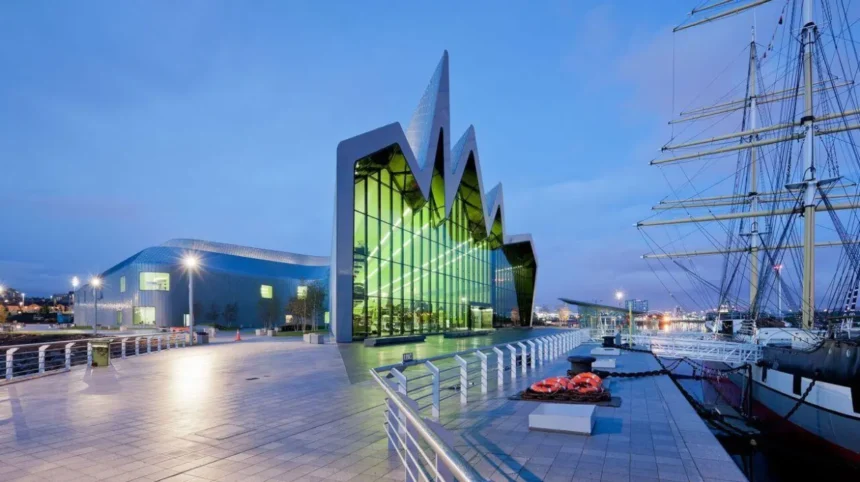
The Riverside Museum is the strongest starting point for a full Glasgow-to-Cambuslang riverside walk because the Clyde Walkway begins beside the museum and Tall Ship, with public transport access through Govan and Partick before the path continues towards Glasgow city centre and Cambuslang.
The Riverside Museum stands beside the River Clyde at the junction of the Clyde and River Kelvin. Glasgow Life describes it as a transport and technology museum reflecting Glasgow’s industrial history, including shipbuilding, engineering and railway manufacturing.
The museum provides a useful landmark for beginning the walk because the Clyde Walkway starts near the Tall Ship and Riverside Museum.
Govan Subway station is approximately 0.3 miles from Riverside Museum, while Partick Interchange is approximately 0.6 miles away. The Govan-Partick Bridge provides a pedestrian connection across the Clyde.
This makes the western end convenient for walkers travelling without a car.
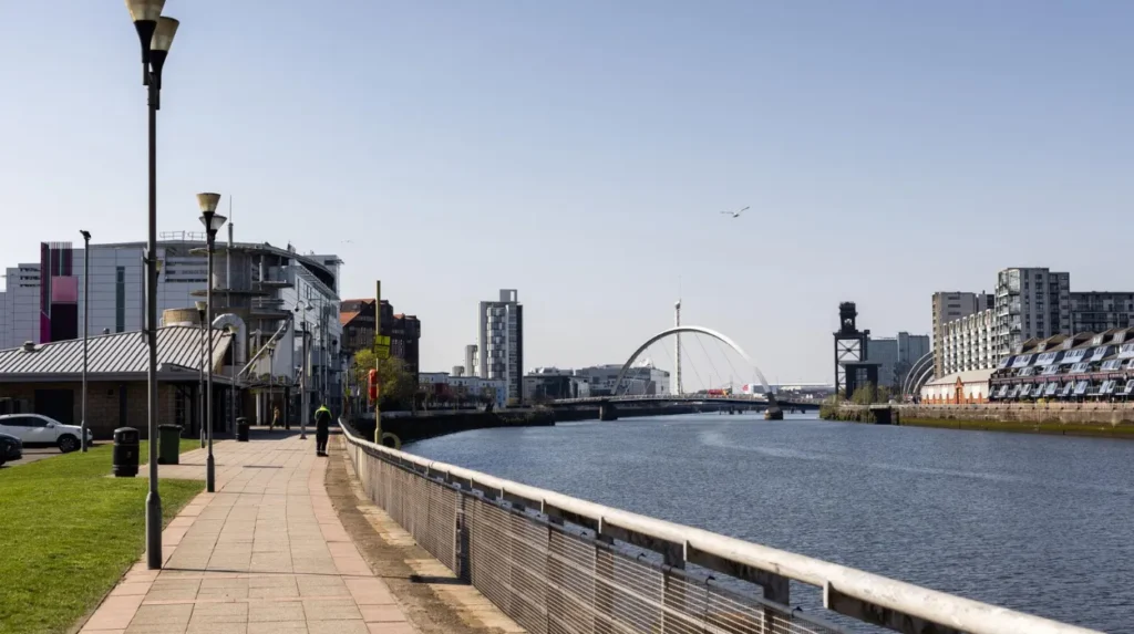
Starting at Riverside Museum also places the walk immediately within Glasgow’s maritime landscape. The route then passes through the waterfront districts associated with shipbuilding, docks and later regeneration.
How long is the Glasgow to Cambuslang Clyde Walkway?
The Glasgow-to-Cambuslang section is approximately 14.5 kilometres, or 9 miles, and takes about 3.5 to 4 hours according to current route information. The route is predominantly flat, with only around 25 metres of recorded ascent on the standard first stage.
The distance makes this section substantially longer than a short city-centre stroll but shorter than a full-day long-distance hike.
Walkhighlands records the section at 14.5 kilometres, with an estimated walking time of 3.5 to 4 hours and approximately 25 metres of ascent.
The Ramblers also lists the Glasgow-to-Cambuslang walk at 14.5 kilometres, describing it as a linear route with no major gradients. It notes that much of the surface is tarmac.
The low elevation gain does not mean the route is effortless. Distance is the main physical factor. Four hours of continuous walking on hard surfaces requires appropriate footwear and pacing.
A walker seeking a shorter experience can divide the route into sections. Glasgow Green provides an accessible stopping point, while Dalmarnock and Cuningar Loop provide further opportunities to shorten or extend the outing.
What landmarks can you see along the River Clyde route?
The Glasgow Clyde route passes major landmarks including Riverside Museum, the Tall Ship, Clyde Auditorium, Finnieston Crane, Glasgow city-centre bridges, Glasgow Green, the People’s Palace, Doulton Fountain, Dalmarnock and Cuningar Loop before reaching Cambuslang.
The first part of the route provides a strong concentration of Glasgow’s modern waterfront architecture and industrial heritage.
The Riverside Museum represents the city’s transport and engineering history. Its location beside the Clyde places the museum directly within the landscape shaped by the river.
The Tall Ship Glenlee sits beside the museum. The vessel provides another connection with Glasgow’s maritime past.
Further along the waterfront, walkers encounter the Clyde Auditorium, commonly known as the Armadillo because of its distinctive overlapping exterior forms. The building forms part of the Scottish Event Campus.
The Finnieston Crane is another major industrial landmark. The giant crane represents Glasgow’s former shipbuilding and heavy-engineering economy.
The route then continues towards the historic bridges of the city. Victoria Bridge, Albert Bridge and other crossings illustrate the changing relationship between Glasgow’s road, rail and pedestrian networks.
Glasgow Green provides the principal large open-space section of the city route. The park contains the People’s Palace and Doulton Fountain.
Beyond Glasgow Green, the environment changes. Industrial buildings, railway infrastructure and newer residential development become more prominent before the route reaches Dalmarnock and Cuningar Loop.
How does the route pass through Glasgow Green?
Glasgow Green is one of the most important sections of the Clyde Walkway because the riverside path crosses the city’s oldest public park before continuing east towards Polmadie, Dalmarnock and Cuningar Loop. The park provides open space within the urban route.
Glasgow Green occupies a major position on the Clyde’s eastern city-centre waterfront.
The riverside path enters the park after the route passes Saltmarket and Albert Bridge. Walkhighlands recommends staying on the path nearest to the Clyde when travelling through the Green.
The park contains several significant landmarks.
The People’s Palace is a museum documenting Glasgow’s social history. Its associated Winter Gardens are also prominent features of the park landscape.
The Doulton Fountain is another major landmark. It is one of Glasgow Green’s best-known monuments.
The Green also has extensive open areas that provide a visual contrast to the surrounding city streets and industrial waterfront.
For walkers starting from Glasgow city centre rather than Riverside Museum, Glasgow Green provides an alternative entry point. Walkhighlands describes a route from Glasgow Central Station down towards the Clyde and then along the riverside path.
This shorter approach is useful for people who want a central Glasgow riverside walk rather than the complete 14.5-kilometre stage.
What is the route like between Glasgow Green and Dalmarnock?
The section between Glasgow Green and Dalmarnock follows the Clyde through a more industrial and regeneration-focused landscape, with riverside paths, bridges, railway infrastructure, residential development and access towards Cuningar Loop creating a clear transition from central Glasgow to the eastern city.
This section demonstrates how strongly the Clyde shaped Glasgow’s industrial geography.
The river corridor contains evidence of former industrial uses alongside newer developments. The landscape includes walls, bridges, railway structures, modern housing and active infrastructure.
Dalmarnock has undergone significant regeneration. The area was associated with the Glasgow 2014 Commonwealth Games, and the former Athletes’ Village became part of the wider residential landscape.
The route also passes near the Dalmarnock Smartbridge, a pedestrian and infrastructure crossing created as part of regeneration associated with the Commonwealth Games.
The Cuningar Loop provides one of the greener sections of the eastern route. It is a woodland and riverside recreation area near Dalmarnock.
The contrast between the industrial corridor and the greener Cuningar Loop demonstrates the changing land use along the Clyde.
Walkers should expect more urban infrastructure here than on the rural sections of the wider Clyde Walkway.
Is the River Clyde walk suitable for beginners?
The Glasgow-to-Cambuslang Clyde Walkway is suitable for walkers with basic fitness because the route is predominantly flat and has no major climbs. Its main challenge is the 14.5-kilometre distance, combined with long stretches of hard-surfaced path.
The route’s low elevation makes it easier than many Scottish countryside walks.
The Ramblers describes the Glasgow-to-Cambuslang section as an easy walk and records no significant gradients. However, it also notes that substantial parts of the route use tarmac.
Beginners should therefore focus on distance rather than hill difficulty.
A person accustomed to shorter walks can use Glasgow Green as a natural stopping point. Another option is to walk from Riverside Museum towards Glasgow Green and return by public transport.
Experienced walkers can continue beyond Cambuslang into the longer Clyde Walkway.
The route’s urban setting also means access to transport and facilities is better than on many long-distance Scottish trails.
Is the Clyde Walkway good for running and cycling?
The Glasgow-to-Cambuslang Clyde Walkway is also used for cycling and running because much of the route follows a riverside cycle path. Users share sections of the route, so walkers, runners and cyclists need to maintain awareness around bridges, junctions and busy shared paths.
The first Clyde Walkway stage follows a good riverside cycle path for much of its length. Walkhighlands specifically identifies the terrain as a riverside cyclepath.
A VisitScotland and Sustrans route document describes an 8.8-mile, 14.1-kilometre Banks of the River Clyde cycling route, which uses sections of the Clyde Walkway and National Cycle Route 75.
This overlap explains why the waterfront can be active with different types of users.
Cyclists should control speed around pedestrians and junctions. Runners should remain aware of approaching bikes. Walkers should avoid blocking the full width of shared paths.
The hard-surfaced route is suitable for steady running, although long-distance runners should account for the repetitive impact of tarmac.
Can you walk the Clyde route with a dog?
Dogs can accompany walkers on suitable public paths along the Clyde, but owners must keep dogs under control around cyclists, pedestrians, roads, bridges, wildlife and other users. Caution is particularly important near urban infrastructure, shared paths and areas containing wildlife or livestock.
The Glasgow section is more suitable for controlled urban dog walking than the rural sections farther along the Clyde Valley.
The route contains shared paths, roads, bridges and developed areas. Dogs should therefore remain close to their owners where necessary.
Cuningar Loop provides an important green-space component of the eastern Glasgow route.
Further along the full Clyde Walkway, the landscape becomes rural. South Lanarkshire Council states that parts of the wider trail cross private land and can contain uneven surfaces, steps and narrow paths.
The wider route also includes agricultural land. Livestock controls apply where relevant.
Dog owners should carry waste bags and use bins where provided. Glasgow City Council community infrastructure records specifically identify requests for improved dog-waste facilities and CCTV around parts of the Clyde Walkway, demonstrating the importance of responsible shared-path use.
Which bridges are important on the River Clyde walk?
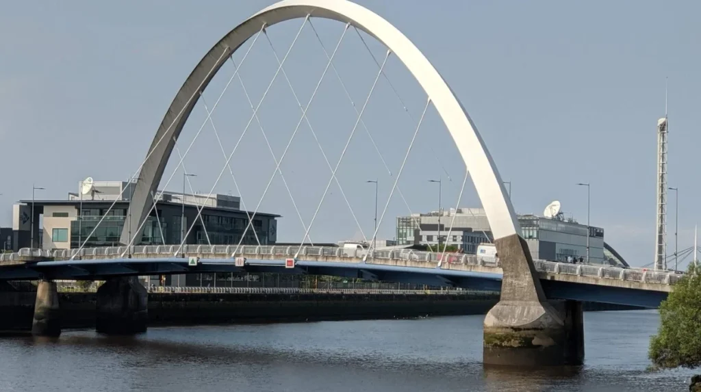
The Clyde route crosses or passes numerous historic and modern bridges, including South Portland Street Suspension Bridge, Victoria Bridge, Albert Bridge, St Andrew’s Suspension Bridge and bridges around Dalmarnock and Cambuslang. These structures reveal the river’s changing transport and industrial importance.
Bridges form an important part of the Clyde’s urban identity.
The South Portland Street Suspension Bridge is an early landmark on the route. Walkhighlands identifies it as one of the first major structures encountered after leaving Riverside Museum.
Victoria Bridge has particular historical importance. Walkhighlands identifies it as the oldest of the Clyde bridges encountered on this section. The route requires a road crossing near the A8 in this area.
The route also passes Albert Bridge near Saltmarket before entering Glasgow Green.
Further east, walkers encounter bridge infrastructure around Dalmarnock, Polmadie and Rutherglen.
Each bridge reflects a different stage of Glasgow’s urban development. Some were built primarily for road or rail transport. Others provide pedestrian or cycling connections.
The bridges also create useful orientation points when navigating the route.
What industrial history can you see beside the Clyde?
The Clyde waterfront contains extensive evidence of Glasgow’s industrial past, particularly shipbuilding, engineering, docks, cranes, railway infrastructure and heavy manufacturing. The riverside walk connects historic industrial structures with modern cultural buildings and regeneration projects along the waterfront.
The River Clyde played a central role in Glasgow’s industrial development.
The city’s shipbuilding industry became internationally significant because the Clyde provided access to shipyards, engineering firms, transport networks and global trade routes.
VisitScotland’s Clyde Waterfront information states that a fifth of all ships in the world were built on the Clyde at its peak, illustrating the scale of the river’s shipbuilding economy.
Many original industrial operations have disappeared, but physical evidence remains.
The Finnieston Crane represents the heavy industrial waterfront. Historic docks and shipyard landscapes remain particularly important around Govan and the wider Clydeside area.
The Riverside Museum provides additional historical context. Glasgow Life states that its collections reflect Glasgow’s contribution to shipbuilding, train manufacturing and engineering.
The river’s industrial heritage is therefore not limited to individual monuments. It is embedded in the wider pattern of bridges, docks, quays, warehouses, cranes and transport infrastructure.
How has the River Clyde waterfront changed?
The River Clyde waterfront has shifted from a predominantly industrial corridor towards a mixed urban environment containing housing, offices, cultural venues, leisure facilities, public spaces and active-travel infrastructure while retaining important industrial and maritime heritage sites.
Glasgow City Council identifies the Clyde as a major part of the city’s economic and social history and a strategic asset for future regeneration.
The River Clyde Development Corridor framework promotes an accessible waterfront with improved connections, public spaces, housing, heritage protection and climate resilience.
Recent infrastructure programmes also focus on improving pedestrian and cycling access to the river.
Glasgow City Council’s work on the Broomielaw and Clyde Street area includes objectives to improve access to the River Clyde by reducing vehicle dominance and strengthening pedestrian and active-travel connections.
The Riverside Museum area also forms part of ongoing waterfront regeneration. Glasgow Life identifies plans associated with Yorkhill Quay and a future riverside walkway connecting with the existing path network.
These projects reinforce the importance of walking as a way to experience the Clyde.
What is the best one-way route for a first-time visitor?
For a first-time visitor, the strongest one-way route is Riverside Museum and Tall Ship → Finnieston → Broomielaw and city-centre bridges → Glasgow Green → Polmadie → Dalmarnock → Cuningar Loop → Cambuslang. It covers the main urban Clyde experience in one continuous walk.
Starting at Riverside Museum provides immediate access to the waterfront and major cultural attractions.
From there, follow the Clyde eastwards. The route passes the modern Scottish Event Campus area and Finnieston Crane before reaching the central waterfront.
Continue towards the city-centre bridges. Victoria Bridge and Albert Bridge provide important reference points.
After Saltmarket, enter Glasgow Green and remain on the riverside side of the park.
Continue east beyond Glasgow Green. The landscape becomes more industrial and then transitions through Dalmarnock towards Cuningar Loop.
The route eventually reaches Cambuslang Bridge. Cambuslang provides a practical endpoint because public transport is available nearby.
This linear format avoids the need to retrace the entire route.
The total distance is approximately 14.5 kilometres, with an estimated walking time of 3.5 to 4 hours.
Are there shorter River Clyde walks in Glasgow?
Shorter Clyde walks are available by using sections of the full Clyde Walkway rather than completing the 14.5-kilometre Glasgow-to-Cambuslang stage. Glasgow Green, the city-centre waterfront, Riverside Museum and Govan provide practical starting and stopping areas for shorter riverside outings.
A short city-centre option begins near Glasgow Central Station and heads towards the Clyde before joining the riverside path. Walkhighlands identifies this as a route towards Glasgow Green and the Clyde Walkway.
Another option is the waterfront between Riverside Museum and Govan.
The Govan-Partick Bridge connects the two sides of the Clyde and provides direct pedestrian access to Riverside Museum. Glasgow Life states that the museum is around a five-minute walk from Govan Subway station when using the bridge.
VisitScotland also lists a guided Clyde Waterfront Walk between the city centre and Govan Cross, focusing on maritime history, lost docks and Govan’s historic dry docks.
These shorter routes work well when the objective is sightseeing rather than completing a long-distance walk.
Explore More Area Guide
Best Walking and Hiking Routes Near Glasgow 2026
Best Glasgow Parks for Running, Cycling and Dogs 2026
What should you know before walking the River Clyde route?
Walkers should check current path conditions, construction diversions, weather, transport and accessibility before starting. The Clyde Walkway is a shared route with changing urban infrastructure, and some sections of the wider 65-kilometre trail have temporary or permanent access restrictions.
Path conditions change over time because of construction, regeneration, weather and maintenance.
Current route information from Walkhighlands records a closure on a later Clyde Walkway section between the Riverside Transport Museum and Clydeside Distillery, with a diversion described across the Clydeside Expressway. The source notes an expected reopening in late summer 2026 and advises checking whether the section has reopened.
This is particularly relevant for anyone attempting to follow the full Clyde Walkway rather than only the Glasgow-to-Cambuslang section.
South Lanarkshire Council also identifies a separate closure farther along the wider route between Poplar Glen and Milton Lockhart because of unsafe structures.
The route is not fully accessible throughout its entire 65-kilometre length. South Lanarkshire Council states that some sections contain uneven surfaces, steps or narrow paths.
For a Glasgow city walk, comfortable footwear, water and weather-appropriate clothing are practical requirements. Walkers should also use official signs and current route information where diversions exist.
What is the final recommended River Clyde walking route?
The recommended Glasgow River Clyde walk is the 14.5-kilometre Clyde Walkway section from Riverside Museum to Cambuslang. It combines maritime heritage, modern architecture, historic bridges, Glasgow Green, Dalmarnock and Cuningar Loop with low elevation and reliable public transport access.
For visitors who want the most complete single-day introduction to the Clyde inside Glasgow, this section provides the strongest combination of distance, landmarks and river access.
The western start at Riverside Museum introduces Glasgow’s maritime and engineering heritage. The route then moves through the modern waterfront and central bridges before reaching Glasgow Green.
The eastern section provides a different perspective. Dalmarnock demonstrates regeneration around former industrial land, while Cuningar Loop adds woodland and open space.
The route is also practical because it is linear. Walkers do not need to complete a return journey on foot.
For shorter walks, the city-centre Clyde and Glasgow Green sections provide flexible alternatives. For long-distance hikers, the route continues beyond Cambuslang towards Strathclyde Country Park, the Clyde Valley and New Lanark.
The wider Clyde Walkway remains one of the most significant riverside trails around Glasgow because it connects the city’s industrial waterfront with the natural and historic landscapes of the Clyde Valley. Scotland’s Great Trails records the complete route at 65 kilometres, linking Glasgow with New Lanark.
The best choice therefore depends on walking distance. For a single Glasgow riverside day walk, choose Riverside Museum to Cambuslang. For a short city walk, use the Glasgow Green and central waterfront sections. For a multi-day walking challenge, follow the full Clyde Walkway towards New Lanark.
What is the best route to walk along the River Clyde in Glasgow?
The best full Glasgow riverside route is the Clyde Walkway from Riverside Museum to Cambuslang. It covers approximately 14.5 kilometres (9 miles) and takes around 3.5 to 4 hours.