
Key Points
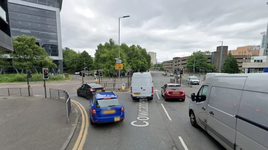
- The latest phase of Glasgow city centre’s transformation has opened to the public at Cowcaddens Road and Dobbie’s Loan.
- The development is part of the wider Avenues Plus project and includes upgraded carriageways, wider footways and dedicated walking, wheeling and cycling infrastructure.
- Improvements include upgraded junctions, modernised pedestrian crossings, additional seating and new urban landscaping.
- The project is funded through the Places for Everyone initiative, backed by the Scottish Government and delivered through Sustrans Scotland, alongside the Glasgow City Region City Deal.
- The work aims to improve active travel links, reduce the dominance of vehicles and connect local communities with the city centre.
Glasgow (Glasgow Express) August 25, 2026 – The latest stage of major streetscape improvements across Glasgow city centre has officially opened, marking a significant milestone in the delivery of the Avenues Plus programme. Works completed along Cowcaddens Road and Dobbie’s Loan have systematically reconfigured key arterial links to establish safer, more accessible routes for individuals walking, wheeling, and cycling. The completed works introduce widened footways, segregated active travel corridors, fully upgraded pedestrian crossings, improved junction layouts, public seating installations, and extensive green landscaping designed to modernize the street environment.
- Key Points
- How does the Avenues Plus project fit into Glasgow’s wider urban transformation?
- What specific infrastructure upgrades have been delivered for pedestrians and cyclists?
- Background of the particular development
- Prediction: How this development can affect local residents, commuters, and businesses
The project represents a core component of the broader Avenues and Avenues Plus initiative, supported by funding from the Scottish Government’s Places for Everyone programme—administered through Sustrans Scotland—and the Glasgow City Region City Deal. By reallocating road space previously dedicated exclusively to motor traffic, the infrastructure seeks to integrate the northern periphery of the city centre with surrounding residential neighbourhoods, including Cowcaddens, Dundasvale, and Townhead.
How does the Avenues Plus project fit into Glasgow’s wider urban transformation?
The scheme operates alongside the primary Glasgow City Centre Avenues programme, an ambitious city-wide infrastructure undertaking designed to redesign the urban core’s street network. While the main Avenues portfolio targets high-density commercial thoroughfares such as Sauchiehall Street, Argyle Street, and George Square, the Avenues Plus project focuses on critical fringe corridors that feed directly into the central precinct.
The intervention along Cowcaddens Road and Dobbie’s Loan addresses long-standing spatial divisions created by mid-twentieth-century road infrastructure. Through the installation of high-quality paving, intelligent street lighting, rain gardens, and targeted tree planting, the physical environment has been adapted to mitigate urban heat island effects, improve surface water drainage, and create a visually welcoming entry point into the city core.
What specific infrastructure upgrades have been delivered for pedestrians and cyclists?
The infrastructure layout along the Cowcaddens Road and Dobbie’s Loan corridor incorporates several structural modifications designed to improve active travel safety and traffic management:
- Segregated Cycle Tracks: Continuous bi-directional and single-track cycle paths physically separated from motorized traffic lanes to prevent vehicle encroachment.
- Footway Expansion: Substantial widening of pedestrian pavements to enhance accessibility for wheelchair users, pushchairs, and high-density foot traffic.
- Junction Realignments: Redesigned intersections featuring reduced turning radii for motor vehicles, forcing lower transit speeds and shortening crossing distances for pedestrians.
- Signalised Crossings: Modernized, accessible pedestrian and cyclist crossing points equipped with tactile paving and priority signal phasing.
- Street Furniture and Greening: Integration of durable public seating alongside sustainable urban drainage systems (SuDS) and selected tree species to bolster urban biodiversity.
Background of the particular development
The Glasgow City Centre Avenues project was conceived as part of the Glasgow City Region City Deal—a £1.13 billion infrastructure investment funded jointly by the UK Government, the Scottish Government, and eight local authorities. The primary aim of the streetscape strategy is to reverse decades of car-centric urban design, which saw Glasgow’s city centre encircled and bisected by high-capacity carriageways during the latter half of the twentieth century.
The specific “Avenues Plus” strand was established to ensure that adjacent residential areas bordering the commercial core were not left isolated by main-avenue developments. Supported by Sustrans Scotland’s Places for Everyone fund, Avenues Plus covers four key geographic zones: Cowcaddens Road/Dobbie’s Loan, Duke Street/John Knox Street, South Portland Street, and Broad Street. Planning, public consultations, and site assessments for the Cowcaddens and Dobbie’s Loan section commenced following extensive spatial reviews aimed at resolving pedestrian bottlenecks and addressing poor cycle connectivity near major transport nodes, including Cowcaddens Subway Station and Buchanan Bus Station.
Prediction: How this development can affect local residents, commuters, and businesses
Impact on Local Residents and Active Travellers
Residents of Cowcaddens, Townhead, and the northern city boundaries will experience direct improvements in neighborhood accessibility. The physical segregation of cycle routes and footway expansions reduces collision risks, likely encouraging higher rates of short-distance walking and cycling among non-drivers, elderly residents, and families. Enhanced lighting and open sightlines are also anticipated to improve public perception of safety during night-time hours.
Impact on Commuters and Public Transport Users
Commuters transferring between regional bus services at Buchanan Bus Station, Cowcaddens Subway Station, and nearby educational campuses (such as Glasgow Caledonian University and the City of Glasgow College) gain smoother, barrier-free transit corridors. Conversely, motorists navigating the northern edge of the city centre may experience altered traffic flows and adjusted lane capacities, encouraging long-distance vehicular traffic to utilize surrounding strategic routes rather than inner-city surface streets.
Impact on Local Commercial and Educational Institutions
Local businesses, retail outlets, and educational facilities located along the corridor stand to benefit from increased footfall generated by enhanced pedestrian connectivity. Improved public realm aesthetics traditionally support economic vitality by creating environments where visitors spend more time. Furthermore, the alignment of active travel infrastructure supports Glasgow’s broader strategic targets to achieve net-zero carbon emissions, influencing how future commercial developments in the northern quadrant of the city are designed and accessed.