
Key Points
- Glasgow City Council has formally launched a public consultation for the ‘Connecting Anderston’ project, aimed at overhaul of public space and active travel links around Anderston Station.
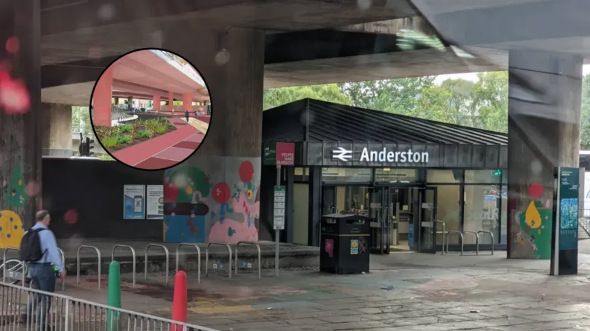
- The proposal seeks to transform the under-motorway concrete space into a greener, accessible public plaza with new paving, planting, rain gardens, seating, cycle parking, and public art.
- The underused stepped footbridge over North Street will be removed and replaced with modern, street-level crossings featuring tactile paving, upgraded traffic lights, step-free access, and improved lighting.
- A new two-way segregated cycle track will connect the almost-completed Avenues route on Argyle Street to existing protected infrastructure on Elderslie Street, closing a critical gap between the city centre and West End.
- Surface designs in the proposed plaza will draw direct inspiration from Anderston’s rich historical weaving heritage.
- Public feedback is open online until 22 November 2026, supported by a drop-in event at The Pyramid at Anderston on 21 October 2026.
Glasgow Council (Glasgow Express) October 15, 2026 – Comprehensive urban transformation proposals designed to create a greener public gateway and bridge the transport divide between Glasgow’s city centre and the West End have officially entered public consultation.
- Key Points
- What Are the Key Structural Changes Proposed for the M8 and North Street Crossings?
- How Will the Project Complete Glasgow’s Active Travel Network Between the City Centre and West End?
- What Did Key Officials and Community Leaders Say About the Proposals?
- How Can Local Residents and Businesses Participate in the Public Consultation?
- What Is the Historical and Operational Background of the Anderston Development?
- How Could This Development Affect Local Residents, Commuters, and Local Businesses?
The project, titled ‘Connecting Anderston’, targets the concrete infrastructure surrounding Anderston Station and the overhead M8 motorway corridor. Designed to mitigate decades of physical severance caused by major road networks, the scheme introduces sweeping public realm upgrades, street-level pedestrian crossings, and dedicated cycling infrastructure.
As detailed in the official launch by Glasgow City Council, the initiative focuses on turning the underutilised space around Anderston Station into a vibrant public plaza. The redesign encompasses new surface paving, integrated planting, rain gardens, public seating, secure cycle storage, and spaces dedicated to public artwork. To establish a distinct local identity, the visual surface treatments will draw inspiration from Anderston’s historical weaving industry, whilst multi-tiered landscaping will soften the heavy infrastructure of the adjacent M8 motorway and manage surface water runoff.
What Are the Key Structural Changes Proposed for the M8 and North Street Crossings?
A central element of the draft plan involves dismantling the existing stepped footbridge over North Street. Urban planners have designated the structure underused and a physical barrier to inclusive mobility. In its place, the council proposes fully accessible street-level signalised crossings designed to make journeys across North Street significantly safer, more direct, and step-free.
The infrastructure package also incorporates upgraded traffic signal technology, tactile paving, energy-efficient street lighting, and clear, comprehensive wayfinding signage to assist pedestrians and wheelers navigating beneath the motorway slip roads.
How Will the Project Complete Glasgow’s Active Travel Network Between the City Centre and West End?
A major priority of the scheme is closing a high-profile gap in Glasgow’s protected active travel route network. Under the proposals, a new two-way segregated cycle track will be constructed along Argyle Street, stretching to the east and west of Anderston Station.
This new track will directly connect the nearly completed Argyle Street West section of the city’s Avenues project with the existing protected cycle lanes on Elderslie Street. Once constructed, the path will complete a continuous, fully segregated walking, wheeling, and cycling line connecting Glasgow city centre directly to the West End.
What Did Key Officials and Community Leaders Say About the Proposals?
As reported by Glasgow City Council Communications, Councillor Angus Millar, City Convener for Transport and Climate, stated that:
“Major roads and motorway infrastructure have long made the area around Anderston Station unpleasant and difficult to navigate. These proposals would create a safer, greener and more accessible public space at Anderston Cross and create a more pleasant link between Anderston and the newly improved Argyle Street West Avenue in the city centre.”
Councillor Millar added that:
“The plans would also close a key gap in the active travel network, creating a more joined-up pedestrian and cycle link from the city centre to the West End through the area around Anderston Station and beneath the M8 to help people get around the city more conveniently and safely. We want residents, businesses and everyone who travels through Anderston to look at the proposals and tell us what would make the biggest difference to the area.”
The proposals have also drawn official commentary from local educational leaders whose schools sit adjacent to the affected motorway corridors.
As reported by the Glasgow City Council Press Office, Allan Lynn, Headteacher of Anderston Primary School, stated that:
“As a school located beside the M8 motorway and Clydeside Expressway, we know the impact that busy roads can have on our local environment. These proposals offer an exciting opportunity to create a greener, safer and more welcoming space for our community. Improved walking, scooting and cycling routes will help connect Anderston more effectively with public transport and neighbouring areas, encouraging healthier and more sustainable ways to travel.”
In addition, as reported by the Glasgow City Council Press Office, Mary Moore, Headteacher of St Patrick’s Primary School, stated that:
“It was great for our pupils and staff to get an early look at the proposals and see what is being considered for an area they know well. Safe, accessible and welcoming public spaces matter to everyone, and we would encourage local people to look at the plans and share their views.”
How Can Local Residents and Businesses Participate in the Public Consultation?
Glasgow City Council has opened a eight-week consultation period to collect community feedback on the draft designs. The public survey is accessible online and will accept submissions until Sunday, 22 November 2026.
To accommodate in-person engagement, a public drop-in exhibition has been scheduled for Wednesday, 21 October 2026, running from 3.30pm to 7.00pm at The Pyramid at Anderston, located at 759 Argyle Street. Paper copies of the consultation documents and survey forms have also been made available to the public at Exchange House (231 George Street), The Pyramid at Anderston, and the National Library of Scotland facility at Kelvin Hall.
The initial design phase and public consultation process form part of Glasgow’s broader active travel framework, supported by funding from Transport Scotland’s Active Travel Infrastructure Fund (ATIF), under which Glasgow City Council was awarded £9.3 million to develop sustainable movement corridors across the municipality.
What Is the Historical and Operational Background of the Anderston Development?
The urban environment surrounding Anderston Station is largely the product of mid-20th-century transportation planning. During the 1960s and 1970s, the construction of the M8 motorway and the inner ring road cut directly through established residential neighborhoods, effectively severing Anderston from Glasgow’s central business district and creating a harsh environment dominated by highway slip roads, heavy traffic, and concrete overpasses.
For several decades, pedestrian movement between the city centre and the West End through Anderston was funnelled through elevated footbridges and dimly lit underpasses. In recent years, Glasgow City Council has pursued a strategic shift under its flagship ‘Avenues’ programme and the ‘Connecting Glasgow’ framework. These urban initiatives aim to re-prioritise street space for pedestrians, wheelers, and cyclists, replace aging concrete footbridges with accessible street-level crossings, and introduce green infrastructure such as sustainable urban drainage systems (SuDS) to handle extreme rainfall events.
How Could This Development Affect Local Residents, Commuters, and Local Businesses?
If fully approved and constructed, the ‘Connecting Anderston’ development is expected to directly impact three main group audiences:
Local Residents and Families
For residents living in Anderston and surrounding streets, the removal of the stepped footbridge and the installation of street-level, step-free crossings will eliminate physical barriers for parents with prams, elderly residents, and individuals with mobility impairments. The addition of rain gardens, public seating, and tree planting will lessen the visual and environmental impact of the M8 motorway, creating a cleaner, quieter, and safer environment for children walking or scooting to nearby schools such as Anderston Primary and St Patrick’s Primary.
Commuters and Daily Travelers
Commuters using Anderston Station or travelling between the West End and the city centre will experience a continuous, fully segregated cycle and active travel highway. By eliminating the current infrastructure gap on Argyle Street, cyclists will no longer have to navigate complex multi-lane junctions alongside motor traffic. Railway passengers accessing the station will also gain a significantly brighter, better-lit, and more direct public gateway.
Local Businesses and Retailers
For local business owners along Argyle Street and within Anderston, improved pedestrian connectivity is designed to increase footfall by linking the commercial heart of the city centre seamlessly with western residential neighbourhoods. Upgraded public realm aesthetics and dedicated cycle parking facilities are anticipated to encourage visitors to spend more time in the area, helping local shops, cafes, and services capitalize on enhanced street vitality.