Key Points
- Archaeological work in Bearsden, near Glasgow, has identified a previously unknown Roman fortlet on the Antonine Wall, the 13th such structure confidently confirmed.
- Initial traces found in 2017 during excavations of three back gardens on Boclair Road by GUARD Archaeology ahead of development.
- Features include kerbed stone foundations of a turf rampart and a parallel ditch, positioned perpendicular to the Antonine Wall’s line.
- Radiocarbon dating of wood from the ditch places it between AD 127-247, aligning with the Antonine Wall’s active period.
- Two sherds of Roman pottery found beneath the rampart’s stone base, confirming Roman association.
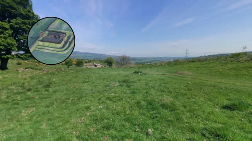
- Site on high ground with views north beyond Roman control and intervisible with the larger Bearsden Roman fort to the west.
- Historic Environment Scotland commissioned expanded excavation and geophysical survey after initial findings.
- Environmental analysis shows surrounding landscape as open pasture with partially cleared woodland of alder, hazel, willow, oak, and birch.
- Research published in Archaeology Reports Online (ARO65) by Maureen Kilpatrick and contributors.
uk/local/bearsden/">Bearsden (Glasgow Express) March 2, 2026 –
Archaeologists from GUARD Archaeology have uncovered evidence of a previously unknown Roman fortlet beneath back gardens along Boclair Road in Bearsden, marking the 13th such structure identified along the Antonine Wall. The discovery emerged during routine excavations in 2017 ahead of residential development, revealing kerbed stone foundations of a turf rampart and a parallel ditch. Historic Environment Scotland, recognising the site’s proximity to the World Heritage-listed Antonine Wall just to the north, commissioned further investigation including a geophysical survey that traced the wall’s probable line through the area.
What Led to the Discovery of the Bearsden Fortlet?
The initial archaeological work took place in the gardens of three adjacent properties on Boclair Road, funded by individual landowners as a condition of planning consents from East Dunbartonshire Council. As reported by Maureen Kilpatrick of GUARD Archaeology in ARO65: Discovery of an Antonine Wall Roman Fortlet at Boclair Road, Bearsden, the kerbed stone base and ditch lay perpendicular to the Antonine Wall’s course, distinguishing them from the wall itself. The expanded excavation uncovered peat deposits, wood fragments, and vegetation in the ditch, while the geophysical survey detected buried stone structures likely part of the wall.
Two sherds of Roman pottery beneath the rampart’s stone base provided early evidence of Roman activity. Wood from the ditch bottom underwent radiocarbon dating, yielding a range of AD 127-247, directly overlapping the period when the Antonine Wall was in use and shortly after. This dating, combined with the features’ scale and orientation, led the team to classify the remains as a fortlet.
Mark Milligan, Managing Editor at HeritageDaily, detailed how the site’s alignment perpendicular to the wall indicated a small defensive outpost rather than part of the frontier itself. The BBC reported on March 13, 2026, that archaeologists believe the fortification formed part of the 2,000-year-old Antonine Wall’s defences.
How Does This Fortlet Fit into the Antonine Wall Network?
The Antonine Wall, constructed around AD 142 under Emperor Antoninus Pius, stretched across central Scotland as the northernmost frontier of Roman Britain, built mainly of turf on a stone base unlike the stone Hadrian’s Wall. Roman forces occupied it for about two decades before withdrawing to Hadrian’s Wall in the AD 160s. This Bearsden fortlet adds to recent discoveries, including those at Carleith Farm in West Dunbartonshire and Bonnyside near Falkirk via Historic Environment Scotland’s geophysical surveys.
Maureen Kilpatrick, who led the work for GUARD Archaeology, stated:
“This fortlet lay on an area of high ground right next to the Antonine Wall. It had commanding views over the landscape, particularly to the north, which was beyond Roman control, and was also intervisible with the larger Roman fort at Bearsden, which lay close-by to the west on lower-lying ground. This suggests that the fortlet was an integral part of the Roman Wall defences, which included forts along its length along with smaller fortlets like this, where small detachments from the larger forts were posted to keep an eye out.”
The site’s strategic position allowed oversight of northern territories outside Roman control and visual signalling with the nearby Bearsden fort. Romansinscotland.com noted the remains were from routine development work but confirmed the fortlet’s association with the wall.
Why Is the 13th Fortlet Significant?
This marks the 13th confidently identified Antonine Wall fortlet, enhancing understanding of the frontier’s defensive density. Previous geophysical surveys by Historic Environment Scotland at Carleith Farm and Bonnyside had revealed others, as referenced in Current Archaeology issues 400 and 403. The Bearsden find underscores how planning-led archaeology preserves such sites amid modern development.
What Evidence Confirms Its Roman Date and Purpose?
Scientific analysis solidified the Roman link. Radiocarbon dating of ditch wood to AD 127-247 aligns precisely with the wall’s era. Roman pottery sherds under the rampart further corroborate this. Environmental study of ditch deposits revealed botanical remains and fossil beetles indicating open pasture with patches of woodland dominated by alder, hazel, and willow, plus oak and birch, and grasses in cleared areas.
The ditch and rampart’s dimensions suit a fortlet for small detachments, perpendicular setup optimising surveillance. HeritageDaily’s Mark Milligan reported that peat, wood, and organic material in the ditch supported dating efforts.
Background of the Antonine Wall Development
The Antonine Wall formed Rome’s northern frontier in Britain, ordered by Antoninus Pius post-AD 142, spanning 37 miles from the Clyde to the Forth. Constructed by the Roman army, it featured forts, fortlets, and a turf wall on stone foundations, manned briefly before abandonment in the 160s AD. Designated a UNESCO World Heritage Site in 2008 alongside Hadrian’s Wall, it reflects Roman efforts to control southern Scotland against northern tribes. The Bearsden fort complements known structures like the Bearsden fort and bathhouse, where artefacts such as a goddess head and gaming board have been found. Planning conditions by East Dunbartonshire Council enabled this discovery, highlighting development’s role in archaeology.
Prediction: Impact on Archaeologists and Historians
This development provides archaeologists and historians with new data on Antonine Wall fortlet distribution and design, potentially prompting targeted geophysical surveys along unsurveyed sections. It may influence future planning policies in Bearsden, requiring enhanced protections near the wall, and enrich public education via sites like the Antonine Wall Trail. For researchers, the site’s environmental data offers insights into local Roman-era ecology, aiding reconstructions of frontier landscapes and military logistics. The full ARO65 report availability supports academic analysis, possibly refining models of Roman withdrawal timelines.