
Key Points
- Public Consultation Launched: Glasgow City Council has opened a public consultation on major transformation proposals for the public realm around Anderston Railway Station.
- M8 Motorway Barrier Removal: The ‘Connecting Anderston’ initiative seeks to tackle long-standing physical barriers caused by the M8 motorway, North Street, and surrounding slip roads to create a safer gateway beneath the highway.
- Public Realm Transformation: Plans feature redesigning the station precinct into a greener plaza complete with rain gardens, new paving, planting, public seating, cycle parking, and public art.
- Footbridge Demolition: The underused stepped footbridge spanning North Street will be removed and replaced with upgraded street-level crossings to ensure direct, step-free access.
- Active Travel Network Expansion: A new two-way cycle track will be built to the east and west of Anderston Station, linking the Argyle Street Avenues route to Elderslie Street’s existing protected infrastructure.
- Cultural Heritage Design: Surface treatments inspired by the traditional weaving history of Anderston will be incorporated to foster a distinctive local identity.
Glasgow (Glasgow Express) October 13, 2026 — Plans to transform the public realm around Anderston Station and improve connections between Glasgow city centre and the West End have been officially opened for public consultation.
- Key Points
- How Will the Public Realm Around Anderston Station Be Redesigned?
- What Structural Changes Are Proposed for North Street Pedestrian Crossings?
- How Does the Scheme Connect Glasgow’s Cycling Network Between the City Centre and West End?
- What Statements Have Civic Leaders Made Regarding the Consultation?
- Background of the Development
- Prediction: How Will This Development Affect Local Residents, Commuters, and Businesses?
The infrastructure project, titled ‘Connecting Anderston’, seeks to establish a safer, greener gateway beneath the M8 motorway while establishing accessible walking and wheeling routes that close a critical missing link in the city’s protected cycle network.
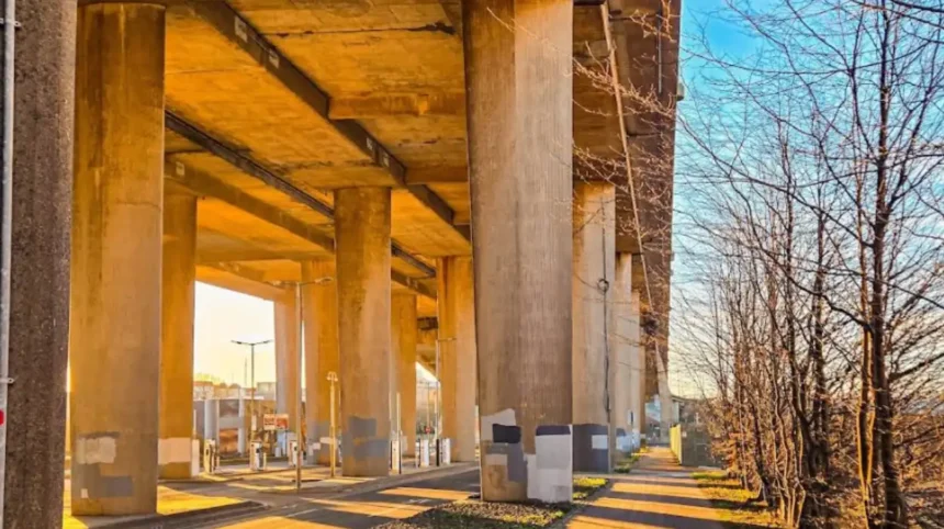
As reported by Glasgow City Council, the overarching project aims to directly address the physical barriers created by the M8, North Street, and adjacent slip roads, which currently make the district unattractive and difficult to navigate for pedestrians, wheelers, and cyclists.
How Will the Public Realm Around Anderston Station Be Redesigned?
Under the proposed plans, the immediate environment surrounding Anderston Station will undergo a complete visual and functional redesign to emerge as a greener public plaza.
The proposed upgrades include:
- Green Infrastructure: Comprehensive new landscaping, planting schemes, and integrated rain gardens designed to soften the heavy concrete setting of the surrounding motorway while managing surface water runoff.
- Street Amenities: High-quality new paving, dedicated public seating areas, secure cycle parking facilities, and curated opportunities for public art installations.
- Local Identity: Modern surface treatments drawing direct aesthetic inspiration from Anderston’s historical weaving heritage, giving the public realm a distinct local character.
What Structural Changes Are Proposed for North Street Pedestrian Crossings?
A core component of the public realm scheme involves dismantling the underused, stepped footbridge over North Street.
The structural modification will see the elevated walkway replaced by modernized, street-level pedestrian crossings. To guarantee overall accessibility and safety, the updated crossing design features step-free routes, tactile paving for visually impaired users, upgraded traffic signal controls, enhanced street lighting, and clearer directional wayfinding signage throughout the transit corridor.
How Does the Scheme Connect Glasgow’s Cycling Network Between the City Centre and West End?
The proposal sets out construction plans for a dedicated two-way cycle track running to the east and west of Anderston Station.
This infrastructure segment will connect the near-complete Avenues active travel route on Argyle Street directly with the existing protected cycling lanes on Elderslie Street. Once completed, the scheme will form a continuous, fully protected active travel corridor spanning all the way from the city centre through to the West End.
What Statements Have Civic Leaders Made Regarding the Consultation?
As reported by the Glasgow City Council Press Office, Councillor Angus Millar, City Convener for Transport and Climate, detailed the scope and goals of the revitalization project:
“Major roads and motorway infrastructure have long made the area around Anderston Station unpleasant and difficult to navigate,” stated Councillor Angus Millar.
“These proposals would create a safer, greener and more accessible public space at Anderston Cross and create a more pleasant link between Anderston and the newly improved Argyle Street West Avenue in the city centre.
“The plans would also close a key gap in the active travel network, creating a more joined-up pedestrian and cycle link from the city centre to the West End through the area around Anderston Station and beneath the M8 to help people get around the city more conveniently and safely.
“We want residents, businesses and everyone who travels through Anderston to look at the proposals and tell us what would make the biggest difference to the area.”
Background of the Development
The district of Anderston historically served as one of Glasgow’s prominent industrial and weaving hubs, densely built with tenements and local trade connections leading down to the River Clyde. However, mid-20th-century urban renewal initiatives radically altered the landscape of the area.
The construction of the M8 motorway during the late 1960s and 1970s severed Anderston’s historic grid system, cutting off direct pedestrian routes between the West End and Glasgow city centre. Over the subsequent decades, high-speed slip roads, multi-lane carriageways, and elevated concrete footbridges dominated the topography around North Street and Anderston Station, creating severe severance effects for surrounding communities.
In recent years, Glasgow City Council has actively pursued urban regeneration strategies through its flagship Avenues Project and Active Travel Strategy. These programs aim to rebalance public thoroughfares away from motor vehicle dominance in favor of pedestrian priority, urban greening, sustainable drainage, and segregated cycle lanes.
The ‘Connecting Anderston’ proposal represents the latest phase of this strategic framework, designed to tie together recent investments along Argyle Street West with long-standing urban regeneration objectives underneath the M8 corridor.
Prediction: How Will This Development Affect Local Residents, Commuters, and Businesses?
Impact on Local Residents and Pedestrians
For residents living in Anderston and adjacent communities, the removal of the steep, stepped footbridge over North Street in favor of modern, step-free street-level crossings will immediately enhance daily mobility. Wheelchair users, parents with prams, and individuals with reduced mobility will gain seamless access across North Street, eliminating physical barriers that have restricted localized foot travel for decades. Furthermore, the introduction of sustainable urban drainage systems (rain gardens) and green landscaping is anticipated to mitigate surface water flooding while lessening the visual severity of the nearby M8 infrastructure.
Impact on Commuters and Cyclists
Daily rail commuters using Anderston Station will experience a significantly upgraded transit gateway featuring better lighting, clearer wayfinding, and integrated cycle parking. For cyclists, the construction of the two-way cycle track removes a major gap between the West End and the city centre active travel networks. Commuters will no longer be forced to navigate high-volume traffic slip roads, resulting in safer journeys and likely driving higher adoption rates of cycling for daily travel.
Impact on Local Businesses and the Retail Economy
Local businesses along Argyle Street and within the immediate vicinity of Anderston Station stand to benefit from increased footfall generated by enhanced public space and safer walking routes. Improved aesthetic appeal and dedicated seating areas encourage pedestrians to spend more time in the district rather than quickly passing through. During the construction phase, temporary localized traffic diversions may occur; however, the long-term establishment of an attractive, cohesive gateway is expected to strengthen local economic viability and better integrate Anderston into the wider commercial life of central Glasgow.